


1. Mansiyon, Bandırma Tasarım Parkı Yarışması
Mimari Açıklama Raporu (İngilizce):1. ANALYSES
1.1. Surrounding
The project area is located at the starting point of Bandırma's western expansion zone. This new development area is divided from the old city with a highly accessible axis that stretches along north-south direction, composed of main land approach from İzmir road that passes through airport, reaches the central train station and eventually the ferry port at the shoreline, connecting the city to megacity, Istanbul. The project area remains at the western side of this corridor, which is currently inactive without development, however promises a lively urban fabric through upcoming plans in near future.
1.2. Historic Values
1.2.1. Units
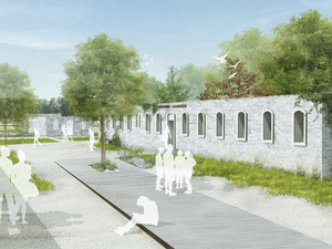
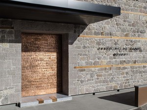
The former military existence has left almost uniformed units in rectangular shapes that are in conservation status those exist specially in the central zone of the site. These units have evolved in time and merged with the natural texture of the area through the natural forces. Currently these units can be considered in three groups according to their level of dissolution within natural landscape as; "enclosed boxes" that somehow conserved all their walls; "open rooms" with semi-ruined structure keeping vegetation out; and "green pockets" with vegetation infiltrated in them.
1.2.2. Composition
The historical units form an elongated grid pattern in north-south axis that exhibits the sea panorama while taking in the strong winds from the same direction. These units gathered mainly in the central zone of the site, dominating the geometry especially at the flat hill top, while superposing its imprint to whole site that contrasts with the freely spread organic pattern of vegetation.
1.3. Natural Values
1.3.1. Vegetation and Topography
The existing vegetation in project site, demonstrates diversity in different parts, and bind strongly with its natural identity. The strong winds in north-south direction, is one of the most powerful natural values of the area which also sculpted the unique form of bended trees in northern part. The topography of the site is elevated from the surrounding areas where an inclined belt of terrain, covers the southern and eastern edge of the site while other higher parts remain quite flat in comparison.
1.3.2. Panorama and Vista
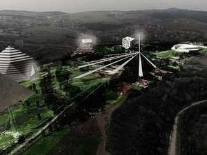
The unique elevated topography gives the site powerful visual connections in all directions. Three dominant panoramas are considered to be an important part of site's identity, which are "mountainscape" in southwest, "seascape" in north, and "cityscape" in east direction.
2. CONCEPT
"Designscapes" is a series of places positioned in different scenes of figure-grounds and panoramas, with multiple user viewpoints on differing scales of observation, reflecting the relation of unit and whole in the absence of borders among built and natural.
2.1. Fusional Units
The two major components of the concept are the built (hard) units, and the natural (soft) units, which are the dominant setup and the essence of the present time site. The former military buildings as hard units and the unique vegetation as soft units are the two major components of identity of the current site that contrast with each other, yet constitute a whole, welded together through time. The passing time, crumbled buildings on one hand, while exhilarated the vegetation in balance, shifting and hollowing the borders between them. This special fusional relationship of dissolving into each other in time is the most important identity value of the site, which also is the main inspiration for the project.
2.2. Combinational Scenes
Two leading elements of the project that are the soft and hard units are spread in the site with changing levels of dominance according to each other. This shifting dominance comes with a combination of figure-ground relations where both hard and soft units can be figure or ground to the other or to themselves, creating four scenes of; soft in soft, hard in soft, hard in hard and soft in hard. These four figure – ground combinations are the main scenes of the project for all the acts to take place.
2.3. Design Experience
Within this framework, Designscapes tells the story of a single fragment of design, its relations with other fragments, the ever redefining borders between them and the multiple points of equilibriums constituting the whole. Following a new perspective of fusion without defined borders between the hard and the soft scapes; Designscapes draws an outline of fragment and whole, on changing scenes of figure and ground. The observations and experiences of users depend on their position in the park that provides isolation from the whole, experiencing a singularity on some times, while having chances to observe the whole in multiple viewpoints on some other.
Aiming to embrace and build on the inspirational figure-ground combinations of scenes, the design park reflects the fusion of units and evolution of the whole in accordance. Thus, the "Designscapes" concept takes the visitors of the park to a journey of multiple viewpoints to understand the relationship of unit and whole through park's existence within city's context; and with the relationship of hard and soft on differing scenes of figure and ground in park's context.
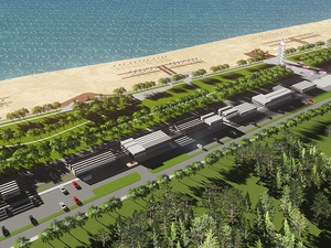
3. PROJECT
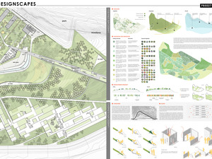
3.1. Urban Diagram
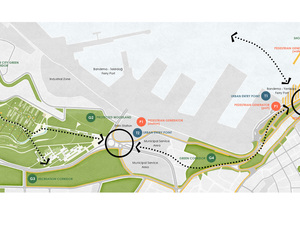
At larger scale, Designscapes aims to vitalize the inactive part of Bandırma city that is divided into two sections with contrasting activity levels of public life. These two sections are the old city part in the east with active public life and south of the port area that is the west of Atatürk Street with lacking spaces for public life. The Designscapes aims to animate the western part of the area by introducing accessible public spaces while connecting the new development areas, in the west of the project site, with the old city; thus connecting and empowering the whole system.
The urban system at larger scale has vital components affecting the project area, which are "entry points", "pedestrian generators" and "green fields". The entry points are the major access points, connecting the city with outer populations; like train station and the ferry port. Another important component is the pedestrian generators, like focal points with central activities, producing a constant flow of pedestrian around them during the day. Places like, Ordu Street, Cumhuriyet Square, Fish Market and Bandırma Pier, determine the pulse of public life in the city. The last component is the green fields, which provide a chance for feeling the nature for city dwellers. This last component is the only one that continues west of the Atatürk Street, going through both northern and southern sides of the project area. The project provides equally active public spaces for the both east and west sides of Atatürk Street in terms of all 3 components, hollowing the border between them.
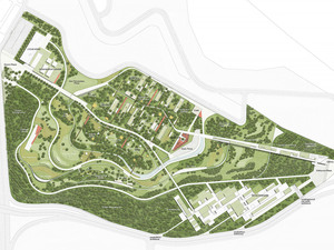
3.2. Site Design
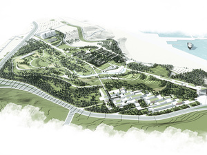
The project places importance to make a connection between the east and the west of the city, as promised on larger scale which is reflected as a sequence of places on east-west axis within the site. This axis is interpreted as such, rather than an explicit corridor, since making a solid connection corridor would risk a division between north and south as well.
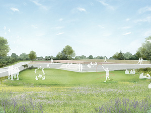
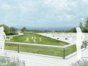
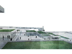
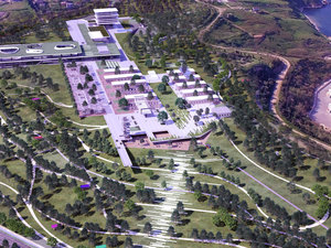
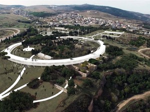
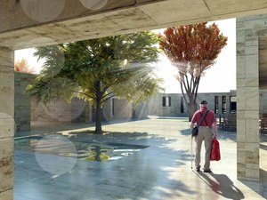
Thus, the sequence of places starts with an entrance plaza on the east, welcoming the old city; and continues through design institute on high elevations till the main plaza where it meets historical buildings. Going through the south of the historical group that host occasional exhibitions and activities; the sequence of places passes through till the panoramic sea plaza and ends at the south of five star hotel and convention centre with a green plaza, connecting the whole system to the new development area on the west. South of this sequence of places, are the loop ribbons with smaller scale places and spatial explorations. The boxes and installations, topographic and vegetative experiences, are placed along these ribbons providing observative, performative and transformative experiences of space on multiple scales.
The design institute itself symbolizes the whole of design, by providing a chance of observing the park at once, together with the 3 main panoramas of sea, mountain and city scapes. The remaining places along the sequence of places and ribbons reflect the fusion of units into each other, making the whole.
3.2.1. Layout Scenario
3.2.1.1. Park / Green
The green belt lies along the western and southern borders of the site, buffering the site from the negative effects of surrounding main roads. In addition to isolating the site from outside, the green belt also lies just behind the ribbons, providing a green background for them to be observed by visitors purely.
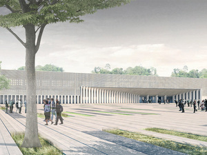
3.2.1.2. Design Institute
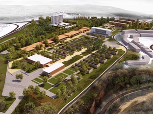
The design institute is located in the eastern side of the site, making the primal connection with the existing city and with users approaching from east. It lies between the entrance plaza in the east and the main plaza at centre, introducing the historical features to users. It gathers spaces for meetings, workshops and symposiums together with a fully open and public green terrace at top.
3.2.1.3. Retail
The retail is located in the eastern part of the site, lying along the south of the design institute, and defining the entrance plaza together with it. It is the only use of the park that makes a direct connection with outside, attracting and inviting the visitors to the inner parts of the park at south eastern border. The grid pattern will introduce a new direction to the system additional to the inspirational historical units.
3.2.1.4. Four Star Hotel
The four star hotel is the other use that shares the southern border with the retail, which on the other hand does not have a connection with outside. Being visually connected to the places along the ribbons, it will stay rather isolated among the green belt that covers the west and south borders of the site.
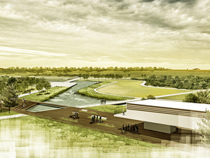
3.2.1.5. Five Star Hotel and Convention Centre
The five star hotel and convention centre are located in the west side of the park, providing a marking place for the visitors approaching from west. They define and neighbour the green plaza in the south and panoramic sea plaza in the east. They will work closely with the design institute located just across the sequence of places.
3.3. Landscape
3.3.1. Landscape Strategy
The existing vegetation is a major component of present site's identity that needs to be conserved and uncluttered, through detailed evaluation and accurate intervention. Therefore the site and the surrounding area are analysed in detail, in view of their present vegetation and condition, topography, vista points and elevation, wind and sea salt effect. The dominant wind direction, combined with the site's position according to the sea, creates a compound effect, influencing mainly the northern side of the area. Despite the dominance of coniferous species, some other deciduous species also exist as; Platanus sp. (Plane), Ficus carica (Fig), Amygdalus communis (Almond), Morus sp. (Mulberry).
The proposed list of plants to be implemented in the design is made up of local species that will support the vegetation, which will not compete with the existing vegetation. The interventions are defined special to the determined 9 zones within the site. These 9 zones are grouped under 3 general strategies of interventions being "protection", "regeneration" and "development" which are all accompanied by side sub-strategies in detail. It is not precise to intervene such a site with a single strategy where conserving the existing vegetation is needed together with the introduction of new ones that are coherent in terms of geography and texture.
3.3.2. Landscape Elements
3.3.2.1. Furniture
Furniture are important to reflect the site's unique identity and character on the public spaces of the project. The iconic skewed trees are the main inspiration for the geometry of the furniture. Together with the unique form; continuity, permeability, availability in vertical and horizontal geometry and adaptation are the main principles, promising that furniture as well to be bendable like the skewed trees to meet future needs of the site.
Considering the diversity of spaces and uses in the project, the furniture are adaptable to be used in activity spaces, exhibition areas, gathering places, paths, and recreational areas. The design follows a modular system that can follow multiple assembly scenarios, and can be expended both in horizontal and vertical dimensions.
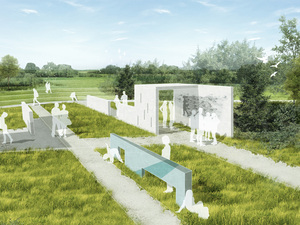
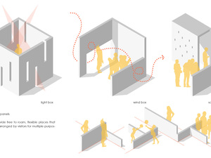
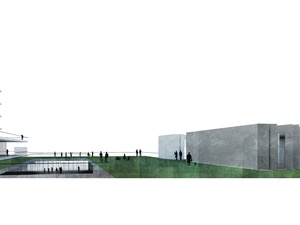
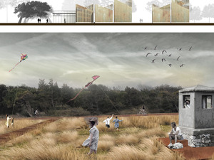
3.3.2.2. Boxes and Installations
Boxes and installations are the landscape elements that are physically inspired by former military buildings, to be filled with a set of defined activities within the park. These structures symbolize the existence and dissolution of hardscape within the soft. All boxes and installations follow an original source built scape and their direction of grid pattern while scattering away from their source.
These boxes and installations can be "observative", "performative" or "transformative" according to their use. Observative units connect the visitors with nature and spatial sensations, like rain, wind, sun, vegetation or other provided spatial explorations. Performative units host productional and exhibitional activities that are mainly design related. Lastly, transformative units give visitors a chance to change the space itself by means of colour, texture or volume; through provided colouring walls, rearrangeable wall and floor tiles and portable smaller units within the unit.
3.4. Architecture
The building program is formed of 4 main functions: Design Institute, 4 Star Hotel, Convention Centre and 5 Star Hotel, and Retail. These functions are considered in terms of their role in defining an east - west pedestrian corridor while providing varying relations between different parts of the city and Designscapes.
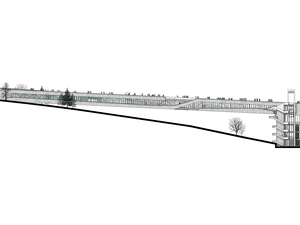
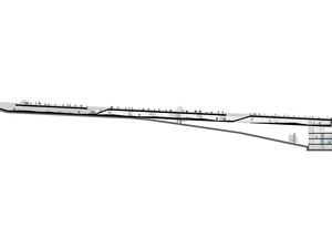
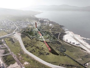
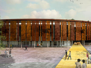
The Design Institute is a bridge that provides a direct link between Designscapes and the old city. It takes the visitors from the plaza on the eastern end of the proposed corridor, elevates them immediately to the upper level through the city library, and through a series of indoor and outdoor experiences. It houses all necessary facilities for academic and social activities within the scope of experiencing, performing, investigating and understanding design disciplines in a single level open space. It is the only single entity building in the park emphasizing the direct link between the park and urban life, and it is generated through the function of Design Institute.
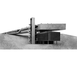
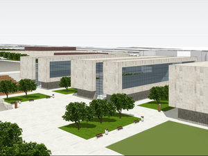
The Convention Centre and 5 Star Hotel are situated on the western edge of the site, aiming to vitalize the public life on the new development areas. The 5 Star Hotel is near the edge of the site and has the potential for its own exterior areas that are not interfering with the park. Building fragments are formed in reference to the geometric configuration of the existing ruins, providing a dialogue between the old and the new.
The 4 Star Hotel and Retail are positioned on the slope at the southern edge of the site. By transforming the slope in dialogue with the parks on the Liman Street, they generate necessary social spaces for the urban life on the new urban development on the south. The fragmented organization gives way to a permeable passage to Designscapes on the upper level.


Tweet